Blackshark.ai, a leading innovator in geospatial technology, announced the official support of the 3D Tiles OGC Community Standard during I/ITSEC23 in Orlando. This expands the integration of their detailed 3D global reconstructions, known from Microsoft Flight Simulator, into a broader spectrum of applications via a globally recognized data standard for geo-referenced training, simulation and visualization use cases.
Cesium, the creators of 3D Tiles and the widely used Cesium ion platform, and blackshark.ai are showcasing the art-of-the-possible based on this exciting announcement.
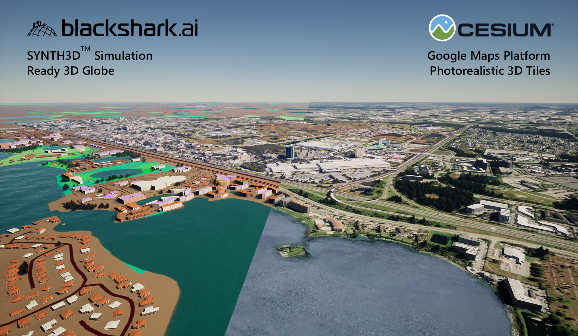
During I/ITSEC you can experience two ways to integrate the announced 3D Tiles support showcased on a 3D model of the Orlando region.
-
- By combining the blackshark.ai Globe Plugin for Unreal Engine providing the according contextual SYNTH3D data with the Cesium for Unreal Engine plugin, streaming in Google Maps Platform Photorealistic 3D Tiles. High-precision geo-referencing and the ability to flexibly define exclusion zones in both plugins allow a watertight combination of both datasets.
- The second showcase provides the same area of Orlando as SYNTH3D data, exported to 3D Tiles, hosted on Cesium ion and visualized with Cesium runtime engines including CesiumJS and Cesium for Unreal Engine. This allows integrators to use Cesium ion functionalities, pipelines, and experiences – with the newly available SYNTH3D data. Cesium is facilitating the showcase of SYNTH3D in 3D Tiles on its Cesium ion platform, providing a clear demonstration of how it works in tandem with the blackshark.ai Globe Plugin and Cesium for Unreal.
Play the video to see how blackshark.ai SYNTH3D and Cesium Google Maps Platform Photorealistic 3D Tiles fit together.
Building upon its notable presence in the industry, recently bolstered by an extended Series A funding round featured on TechCrunch, blackshark.ai continues to refine its solutions that adeptly transform 2D satellite and aerial imagery into photorealistic 3D environments. These digital creations serve a broad spectrum of uses, from training and simulation to complex visualizations.
SYNTH3D is a core part of blackshark.ai’s offerings and is born from the Maxar Vivid 50cm satellite data set to produce a realistic, vectorized, and semantic 3D model of the Earth’s terrain. This model combines a global elevation model, fine 50cm ground texture, regional-specific and geo-typical buildings and vegetation. SYNTH3D’s utility is already proven, with numerous clients having integrated it within their training, simulation, or 3D globe visualization workflows, leveraging blackshark.ai’s software frameworks. The introduction of 3D Tiles support only expands its versatility, allowing SYNTH3D to be hosted, streamed, and integrated across all 3D Tiles-compatible solutions, with Cesium being the leading platform in this space.
Unveiled at I/ITSEC 23, the new export of SYNTH3D as 3D Tiles standard allows for a combination of lightweight, realistic yet simulation-ready data integration, either streamed from servers or self-hosted to all supported runtime engines. This marks a significant enhancement offering users the ease of integrating high-quality 3D models into various platforms and industries.
Visualise blackshark.ai SYNTH3D and Cesium Google Maps Platform Photorealistic 3D Tiles in action with this short demo video.
About Blackshark:
Blackshark.ai is revolutionizing the way we visualize our world by reconstructing the entire globe in photorealistic 3D. As a leader in geospatial data analysis and visualization, blackshark.ai employs AI-driven technology to transform satellite imagery into highly detailed digital environments. Renowned for their contributions to Microsoft Flight Simulator 2020, their platform is pivotal for various applications, including urban planning, simulation, and augmented reality, making them a vital player in the advancement of global mapping and visualization technologies.
About Cesium:
Cesium created 3D Tiles, the Open Geospatial Consortium open standard for streaming massive 3D geospatial data. Use Cesium ion to optimize, host, and combine your data with curated global 3D content, and stream to any device. With unique expertise at the intersection of 3D geospatial and computer graphics, Cesium is deeply committed to openness and interoperability through open standards, open APIs, and open source offerings like CesiumJS, Cesium for Unreal, Cesium for Unity, and Cesium for Omniverse.